Map Background
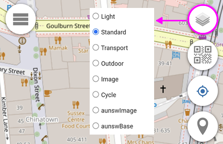
You can define up to 8 Base Maps of your choice.
Base Map 1 is always converted into Grey Scale before being displayed.
Default Base Maps are listed below.
1. Light Base Map
Worldwide
Copyright: OpenStreetMap
Native Zoom Level: 19
Maximum Zoom Level: 23
2. Standard Base Map
Worldwide
Copyright: OpenStreetMap
Native Zoom Level: 19
Maximum Zoom Level: 23
3. Transport Base Map
Worldwide
Map Copyright: Thunderforest
Data Copyright: OpenStreetMap
Native Zoom Level: 22
Maximum Zoom Level: 23
4. Outdoor Base Map
Worldwide
Map Copyright: Thunderforest
Data Copyright: OpenStreetMap
Native Zoom Level: 22
Maximum Zoom Level: 23
5. Image Base Map
Worldwide
Copyright: Esri -- Source: Esri, i-cubed, USDA, USGS, AEX, GeoEye, Getmapping, Aerogrid, IGN, IGP, UPR-EGP, and the GIS User Community
Native Zoom Level: 19
Maximum Zoom Level: 23
6. Cycle Base Map
Worldwide
Map Copyright: OpenStreetMap
Data Copyright: CyclOSM
Native Zoom Level: 20
Maximum Zoom Level: 23
7. aunswImage Base Map
New South Wales Australia only
Copyright: NSW Spatial Services
Native Zoom Level: 21
Maximum Zoom Level: 23
8. aunswBase Map
New South Wales Australia only
Copyright: NSW Spatial Services
Native Zoom Level: 19
Maximum Zoom Level: 23