Region Map
a. Category
The map displayed will be based on the category or categories selected.
b. Area
The map displayed will be based on the status selected.
c. Government
The map displays the area and information of the Local Government Areas (LGAs).
d. Indoor Map
i. Level Browser
A web based viewer for indoor data (inside buildings, level by level) from the OpenStreetMap project.
ii. Floorplan Designer
This is used to draw model buildings with customisable and ready-to-use objects.
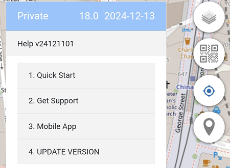
Help
In the example below, the Personal Console is version 24121101
1. Quick Start
A brief explanation what Personal Console is and what it can do.
2. Get Support
This is a place to get help including from other users.
3. Mobile App
Useful OS specific information for Android and iOS
4. UPDATE VERSION
Clicking on the UPDATE VERSION will automatically update Personal Console to the latest version if available.
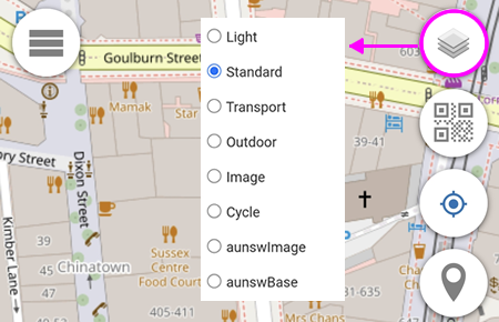
Map Background
You can define up to 8 Base Maps of your choice.
Base Map 1 is always converted into Grey Scale before being displayed.
Default Base Maps are listed below.
1. Light Base Map
Worldwide
Copyright: OpenStreetMap
Native Zoom Level: 19
Maximum Zoom Level: 23
2. Standard Base Map
Worldwide
Copyright: OpenStreetMap
Native Zoom Level: 19
Maximum Zoom Level: 23
3. Transport Base Map
Worldwide
Map Copyright: Thunderforest
Data Copyright: OpenStreetMap
Native Zoom Level: 22
Maximum Zoom Level: 23
4. Outdoor Base Map
Worldwide
Map Copyright: Thunderforest
Data Copyright: OpenStreetMap
Native Zoom Level: 22
Maximum Zoom Level: 23
5. Image Base Map
Worldwide
Copyright: Esri -- Source: Esri, i-cubed, USDA, USGS, AEX, GeoEye, Getmapping, Aerogrid, IGN, IGP, UPR-EGP, and the GIS User Community
Native Zoom Level: 19
Maximum Zoom Level: 23
6. Cycle Base Map
Worldwide
Map Copyright: OpenStreetMap
Data Copyright: CyclOSM
Native Zoom Level: 20
Maximum Zoom Level: 23
7. aunswImage Base Map
New South Wales Australia only
Copyright: NSW Spatial Services
Native Zoom Level: 21
Maximum Zoom Level: 23
8. aunswBase Map
New South Wales Australia only
Copyright: NSW Spatial Services
Native Zoom Level: 19
Maximum Zoom Level: 23
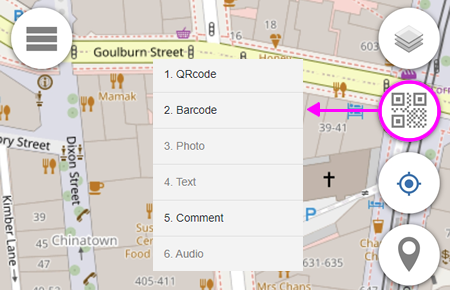
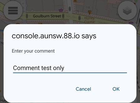
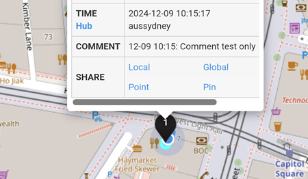
Comment
The Comment feature adds comment to a location pin on the map.
In the example below, the comment entered is
By clcking the OK button, a  pin will be added on the map and clicking on the pin will display the comment entered.
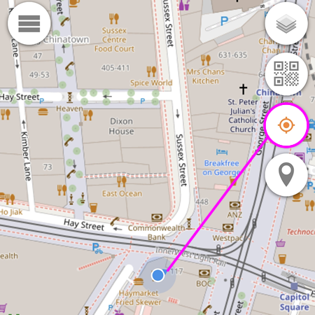
Current Location
Enabling the Current Location button (indicated by the orange circle) will display the current location of the device (indicated by the blue circle).
Disabling the Current Location button will not display the current location of the device.
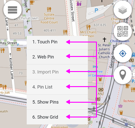
Add Pin
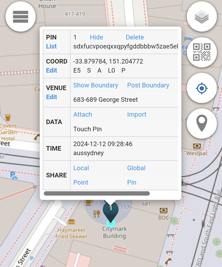
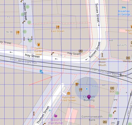
1. Touch Pin
Adding a location pin by touching or clicking on the map.
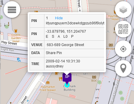
In the example below, the touch pin is added on the Citymark Building which is located at 683-689 George Street.
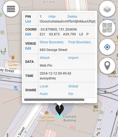
2. Web Pin
A location pin which is added based on the device current location.
In the example below, the device is located somewhere in the Citymark Building.
3. Import Pin
Import Pin is not available for Private Alias users.
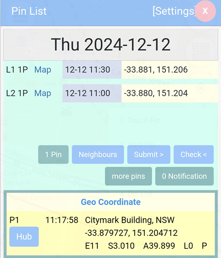
4. Pin List
All pins added are listed here.
In the example below, two pins are added at two different locations and at different time intervals.
1 Pin: displays details about the pin (if there are more than 1 pin, the button will reflect the number of pins).
Neighbours: displays the 8 blocks surrounding the location pin.
Submit >: not available for Private Alias users.
Check <: not available for Private Alias users.
more pins: not available for Private Alias users.
0 Notification: not available for Private Alias users.
Settings
- Display Date: the pins displayed are based on the date specified.
- Display Timezone: set the timezone for the pins.
- Submit Block: local, global, region and district block available.
- Display Block: local or global.
- Display To: shows the pins listed on Pin List up to a selected date.
- Display Length: sets the number of days for pins listed on Pin List to be displayed.
- Display Storage: sets the number of days for pins to be stored.
- Auto Download: automatically download available pins on the day.
- Auto Pin: automatically add pins based on selected time duration.
- No Sleep: prevents console.aunsw.88.io from going to sleep (keeping the display on)
- Submit Status: automatically submit a selected status when a pin is added.
- Submit to Agent: not available for Private Alias users.
- Check Status: set the status to be displayed.
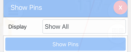
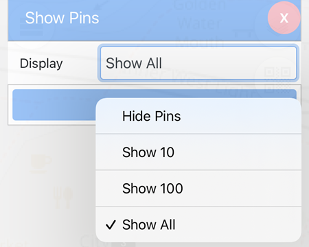
5. Show Pins
By default, the blue button is set to Show Pins.
There are 4 options available from the drop down menu that correspond to the blue Show Pins button:
- Hide Pins: all pins will not be displayed on the map.
- Show 10: displays only the last 10 pins.
- Show 100: displays only the last 100 pins.
- Show All: displays all pins.
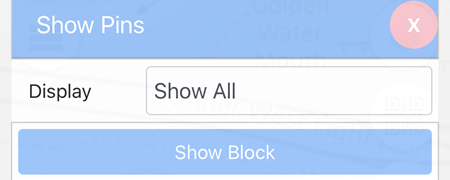
If the blue Show Pins button is clicked, it will toggle to the Show Block button and vice versa.
When the Show Blocked button is clicked, only 1 pin is displayed per block.
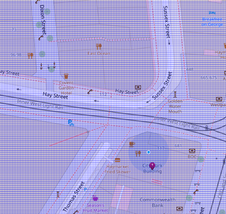
6. Show Grid
The grid width available are 0.001, 0,0001 and 0.00001.
0.001
0,0001
0.00001
Location Pin
Each colour of the location pin represent a different type of pin:
-
 Adjusted Pin (e.g: from venue name change)
-
 Imported Pin (e.g: from Phonetrack)
-
 QR pin
-
 Touch Pin
-
Web Pin
-
 Other Pin (e.g: from Phone Verification)
-
 Share Pin
NOTE:
If the Personal Console window remains open, adding location pins will still work even if there is no internet connection (offline), indicated by the orange Menu button
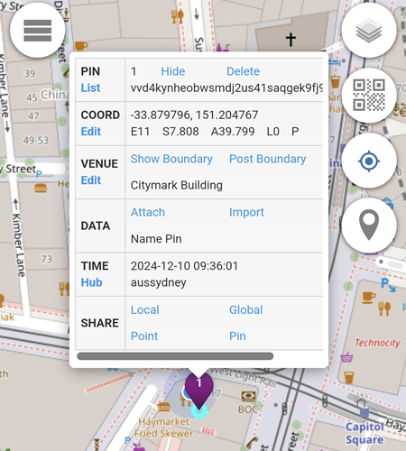
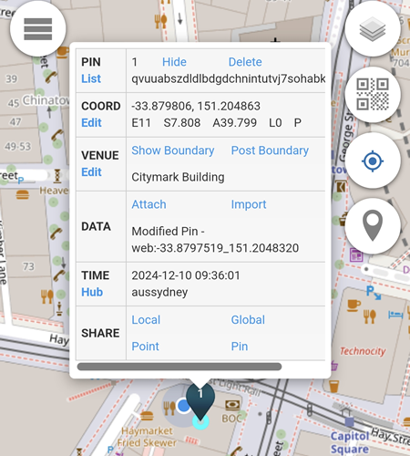
PIN
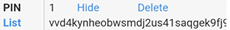
The Hide button will hide the location pin from the map.
To unhide the location pin, click on the  button and select the Show Pins menu.
The Delete button will delete the current location pin permanently.
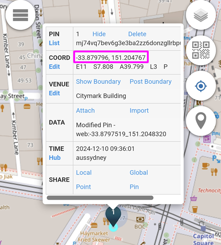
COORD
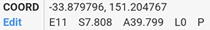
Based on the location pin above:
Latitude: -33.879796
Longitude: 151.204767
E11: error of up to 11 metres
S7.808: speed of 7.808 km/h
A39.799: altitude of 39.799 metres
L0: the ground floor level of the building
P: the pressure value (requires import pin)
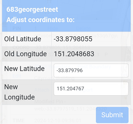
The Edit button will allow users to:
1. Change Coordinates by Touch
By simply using a Touch Pin, the current coordinates will be replaced by the new touch pin. In the example below, the New Latitude and New Longitude are changed to -33.879806 and 151.204863.
2. Change Level
By default, the level used on locations pins will always be L0 (Ground Floor). In the example below, the level is changed to L3 (Level 3)
3. Change Coordinates by Input
In the example below below, the new Latitude and Longitude will be used if submitted.
The location pin with the new latitude and longitude is displayed.
VENUE
Venue is not available for Private Alias users.
DATA
Attach
Attach is not available for Private Alias users.
Import
Import is not available for Private Alias users.
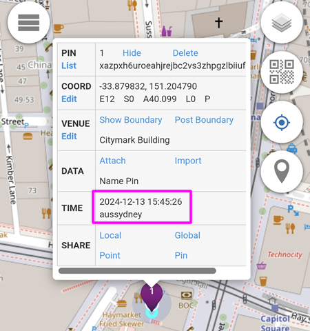
TIME
Time displays the local time in yyyy-mm-dd hh:mm:ss format.
In the example below, the time displayed is:
Year: 2024
Month: 12 (December)
Date: 13
Hour: 15 (3pm)
Minute: 45
Second: 26
aussydney: Australia - Sydney
SHARE
This feature allows the location to be shared via email, SMS, Instant Messaging apps etc.
Local
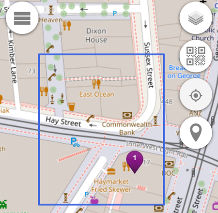
When clicked, a local sharing link copied to clipboard.
In the example below, the local sharing link is https://console.aunsw.88.io/?share=-33.880_151.204_area and the blue rectangle is the result.
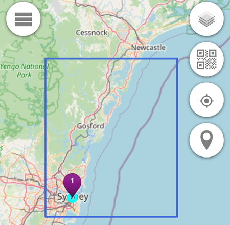
Global
When clicked, a global sharing link copied to clipboard.
In the example below, the global sharing link is https://console.aunsw.88.io/?share=-34_151_global and the blue rectangle is the result.
Point
When clicked, a point sharing link copied to clipboard.
In the example below, the point sharing link is https://console.aunsw.88.io/?share=-33.879796_151.2047677_point.
Pin
The Pin feature is not available for Private Alias users.